Toubkal ascent route details
Pliny, the Roman geographer, described the Atlas peaks as the most fabulous mountains in all of Africa, whilst Louis Neltner (after whom the CAF hut at the base of Toubkal is named) described them as “neither more nor less beautiful than the Alps, but something different”.
The native inhabitants of these mountains are the Berbers, whose name for the High Atlas Mountains is Idraren Draren (Mountains of Mountains). The Toubkal Massif is made up largely of green volcanic rocks, Andesites and Rhyolites, which are fractured and bedded together, producing huge scree slopes. The Toubkal screes are used as a yardstick for comparing similar slopes on other mountains. Do not be put off, those who climb with open minds and unblinkered vision will love it. This highest summit was not assuredly identified until 1922, although Berber tribesmen probably climbed the Atlas long before recorded ascents began.
The first ‘official’ expedition to the Atlas was in 1871 when a small scientific expedition organised by J. D. Hooker was given permission to visit the Toubkal region. The first European to the top of Toubkal was the Marquis de Segonzac in June 1923, and the height of the mountain was determined in 1924, with a trigonometrical signal raised on the summit in 1931. The first British man to the summit was B. Beetham in 1926.
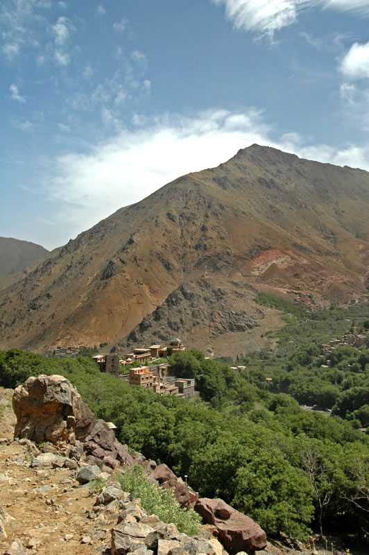
The route we are taking from Imlil to Toubkal is along one of the best used tracks in the High Atlas yet follows one of the most beautiful valleys in Morocco. After leaving the Kasbah, at just over 1800m, we follow a fairly steep zigzag path with a cemetery on our right. This is the path that features in Scorsese’s film Kundun, when the Tibetan monks are returning to the monastery. We fairly quickly join a vehicle track, which takes us through a small gorge, and past the village of Aremd (1920m), built on a peculiar geographical phenomenon called a rock glacier. Beyond the village we cross the ‘basin’ with its fields, orchards and outlying farmhouses to head off up the right hand side of the valley and through the last of the cultivation, as the altitude is now too high and the growing season too short for crops to grow. Beyond here we will see only sheep and goats as we wind up the zigzags towards Sidi Chamharouch (2320m) at about two and a half hours from Imlil.
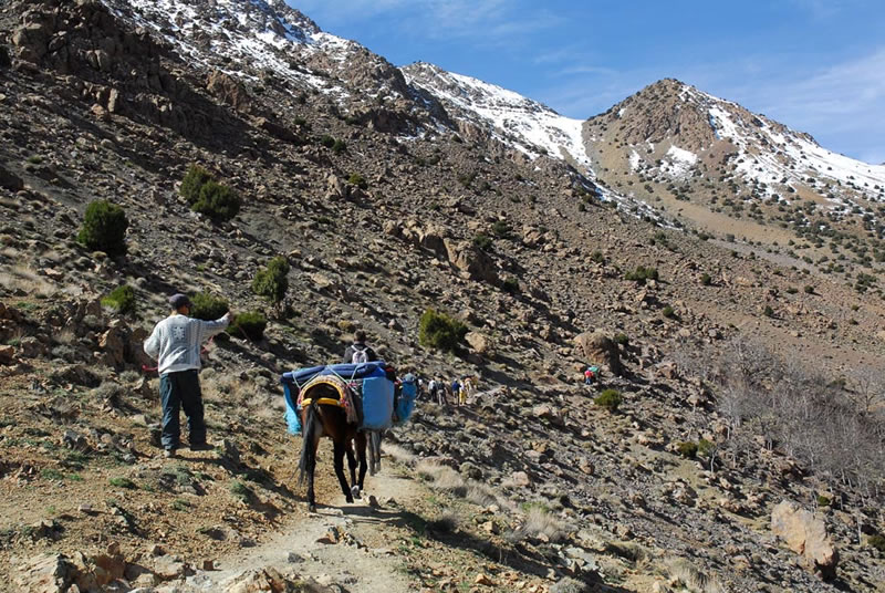
At Sidi Chamarouch there are several small shops and cafes with quite high price, plus a white roofed mosque. This is a popular pilgrimage place for local inhabitants since the source of water, which emerges from the rocks here, is reputed to have healing powers. The waters are supposed to be particularly good for curing leg ailments so we may need to stop here on the way down! Leaving this small settlement, the last this side of the mountains, we follow a steep zigzag path up the right hand side of the valley with the bulk of Toubkal on our left.
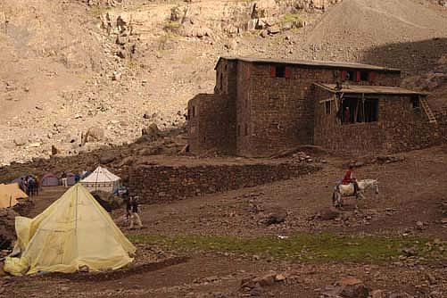
About two hours later as the path levels off the Neltner Hut can be seen in the distance, tucked in well below the col on the skyline. Another twenty minutes and the hut should be reached (3207m). The hut, where we will stay if the weather is poor, is fairly basic and sleeps 30 (at a push), although the CAF (Club Alpin de France) have made recent improvements to it. Our plan is to sleep in a comfortable tented encampment, which will have been pitched for us by our advance party of Berbers, and by camping standards it is really quite luxurious. Portable tented toilets will be provided.
Jbel Toubkal via the South Cwm
This route starts directly behind the Neltner Hut, crossing the small river gorge of the Ait Mizane to find the first of the boulder slopes. A path of sorts, depending on the time of year and the recent weather conditions, ascends for about and hour to reach the large boulders which can be seen on the skyline from the hut. We then follow the path into the main cwm and head right, up a steep scree slope to more gently angled scree leading to Tizi-n-Toubkal (3940m, 2 hours 15 mins).
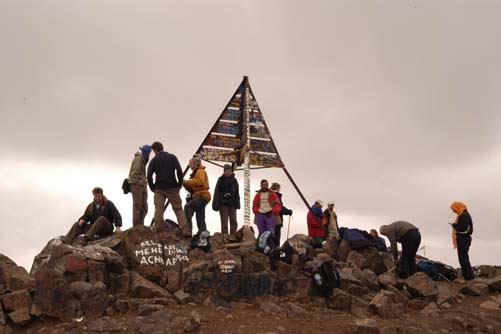
The worst is nearly over although, if you have rarely or never been at this sort of altitude before, you may be feeling a little nauseous and dizzy and will find it hard to believe how slowly you are able to walk. The key is to keep the pace very slow but steady; if you are getting out of breath, slow down even more, rather than stopping. We now follow the ridge to arrive at the summit (3 to 4 hours).
At the summit is a large, iron, pyramidal structure and, haze and weather permitting, excellent views. The best view is probably towards the south, which is of layered distances of the Saharan Plateaux broken by the extinct volcano Siroua. The return to the hut takes about half the time of the ascent, or even less if you are a good scree runner. We will then be returning directly back down to the Kasbah for a well earned shower.
Read Dail Mail Online article about the ascent of Toubkal
Download Dail Mail Online article about the ascent of Toubkal (PDF)
![]()